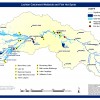
Maps
If you require a laminated, post-sized, hard-copy of any of these resources, or a higher resolution print version, please contact the Lachlan Riverine Working Group (LRWG) Executive Officer .
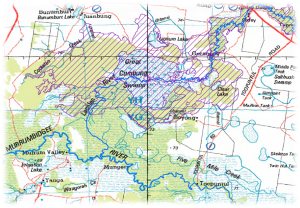
Detailed topographic map of the major rivers and creeks, and Directory of Important Wetlands in Australia (i.e. nationally significant wetlands) in the lower Lachlan (from Lake Brewster to Balranald), September 2010, Environmental Resources Information Network (ERIN), Department of Sustainability, Environment, Water, Population and Communities. Due to large file size, this map can only be obtained by contacting the LRWG Exeucutive Officer, however, the small excerpt to the left of this text demonstrates the resolution of the larger map.
Lachlan Catchment Wetlands (nationally and regionally significant) and Fish Hot Spots’, Local Land Services (formally Lachlan Catchment Management Authority), 2010.
Lachlan River Basin Guaging Stations ‘, March 2011, NSW Office of Water. This map has also been broken up into the following three individual maps of finer resolution and with the list of relevant guaging stations and their numbers. Map 1 Lower Lachlan: Lachlan River above Lake Brewster to confluence with Murrumbidgee River. Map 2 Mid Lachlan: Lachlan River at Gooloogong to Lachlan River below Lake Brewster. Map 3 Upper Lachlan: Lachlan River and major tributories above Gooloogong.
Schematic of the Lachlan Regulated Water Source (NoW).