Climate Change/Variability
Climate Change/Variability
Wyangala Dam approaching its lowest storage level during the Millenium Drought (Image: Casey Proctor, Lachlan CMA, 19 April 2007)
Climate change and/or climate variability needs to be considered in environmental water planning. Most forecasts for the southern Murray–Darling Basin predict reduced water availability which may heavily impact on some water-dependent ecosystems. “Water Availability in the Lachlan: a report to the Australian Government from the CSIRO Murray-Darling Basin Sustainable Yields Project” (CSIRO, 2008), which looks at future climate and current development and impacts on water availability, indicated that future runoff in the Lachlan would be more likely to decrease rather than increase. Under the median estimate 2030 climate the average period between winter–spring inflows to the Booligal Wetlands would increase by a further 24%, although the maximum period between events would not be affected. This would be likely to reduce the frequency of waterbird breeding events in these wetlands. Under the dry extreme 2030 climate, the average period between winter–spring inflows would increase by 87% (to once in over 15 years on average). The maximum period between the events would increase by 47% or by an additional 10 years.

Wyangala Dam spilling at 103% (Photo: Casey Proctor, Lachlan CMA, March 2012)
These changes would be very likely to have major ecological consequences including much longer periods between waterbird breeding events and adverse effects on the status of the Lignum vegetation used as breeding habitat by some waterbirds. Under the median estimate 2030 climate the average period between winter–spring flood events to the Great Cumbung Swamp would increase by a further 24% and the maximum period between events would increase by a further 16%. These increases would be likely to further adversely affect the vegetation of the swamp and its use by waterbirds.
Current and Projected Climate Change in the Lachlan Catchment
CSIRO also prepared a report and brochure on Climate Change in the Lachlan Catchment for the New South Wales Government (2007) aimed at providing information for landowners, landusers and the general public within the Lachlan Catchment. The Brochure summised that in relation to water availability, there is likely to be less water for streams and rivers due to changes in rainfall and high evaporation rates as described in the table below, with consequences for storages and some water-dependent ecosystems similar to that outlined previously. Projections also suggest more droughts and intense storms.
| 1990 | 2030 projection | 2070 projection | |
| Annual average | Crookwell: 860 mm Forbes: 527 mm Ivanhoe: 302 mm Wyalong: 481 mm | -13% to +7% | -40% to +20% |
| Extreme rainfall | -3% to +7% | -7% to +29% | |
| Evaporation | +2% to +13% | +4% to +40% | |
| Droughts per decade | 3 | 2 to 5 | 1 to 10 |
Effects of Drought
Effects of Drought
The Water Sharing Plan for the Lachlan Regulated River Water Source (WSP; as amended 1 July 2004) was suspended the same day it commenced (1 July 2004) due to critical drought conditions, however, the WSP recommenced and has been in effect since 16 September 2011.

Historical comparison of periods of Wyangala Drought Inflows (Image: List Thurtell, OEH, 2009)
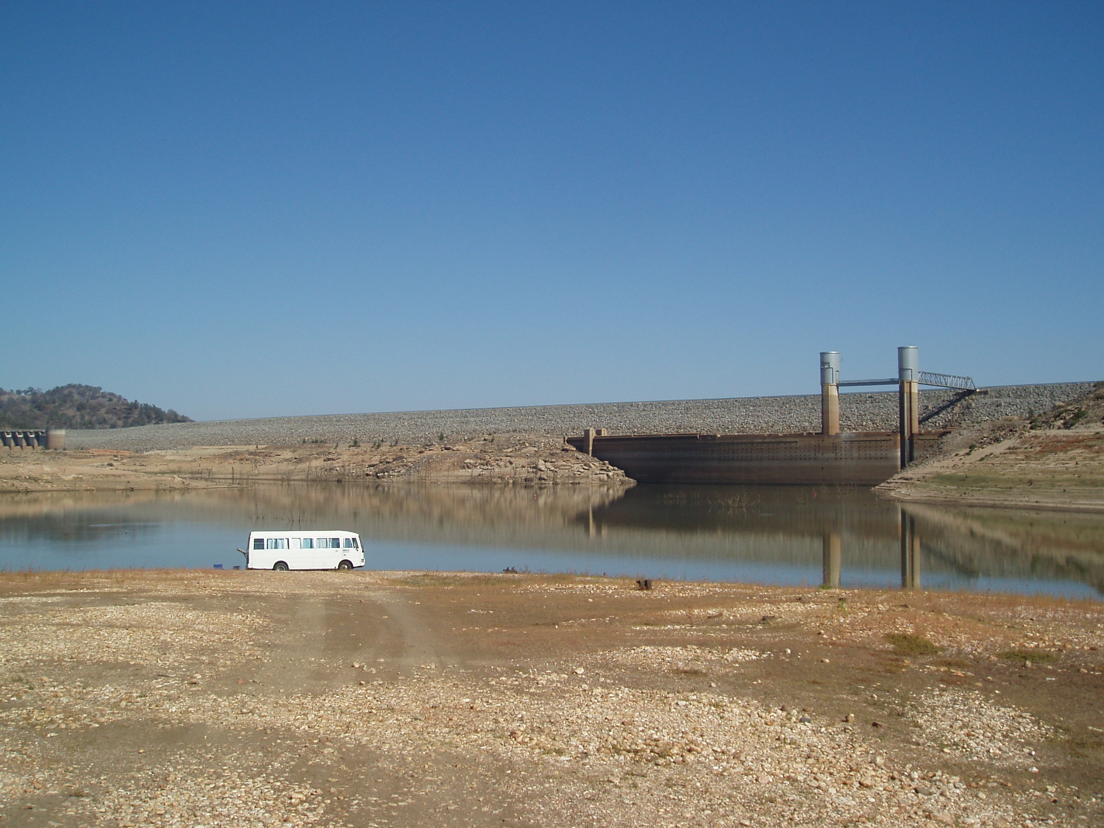
Reduced inflows in the upper catchment led to less water for streams and rivers in the Lachlan Catchment, with downstream consequences for all Lachlan storages which placed a strain on the catchment’s water resources. The Wyangala drought inflows graph to the left indicates that Wyangala Dam received substantially less water since December 2000 than at any other time during the 1900s.
These reduced inflows have seen the two major storages (Wyangala Dam and Carcoar Dam graphs below) in the Lachlan at below 10% for much of the last 6 years, with the exception of 2005/06. State Water data indicates that Wyangala inflows since 2000 have been less than 25% of long term average inflows.

Graph showing the Effective Full Storage Volume (%) in Wyangala Dam from 1960 to January 2014 (Source: NSW Water Information or waterinfo.nsw, data extracted 28 January 2014)
Under the National Water Initiative (NWI), the Commonwealth, State and Territory Governments have agreed that water users should bear the risk of such reductions in water availability, particularly where these may relate to the impacts of climate change. As a consequence, water users within the catchment may face long-term reductions in allocations and higher prices for water.
Lower flows and higher temperatures may also reduce water quality within the catchment. For example, low flows, higher temperatures and elevated nutrients create a more favourable environment for potentially harmful algal blooms (CSIRO 2007). Salinity problems in the catchment may also be exacerbated by reductions in rainfall and dilution flows (Beare & Heaney 2002).
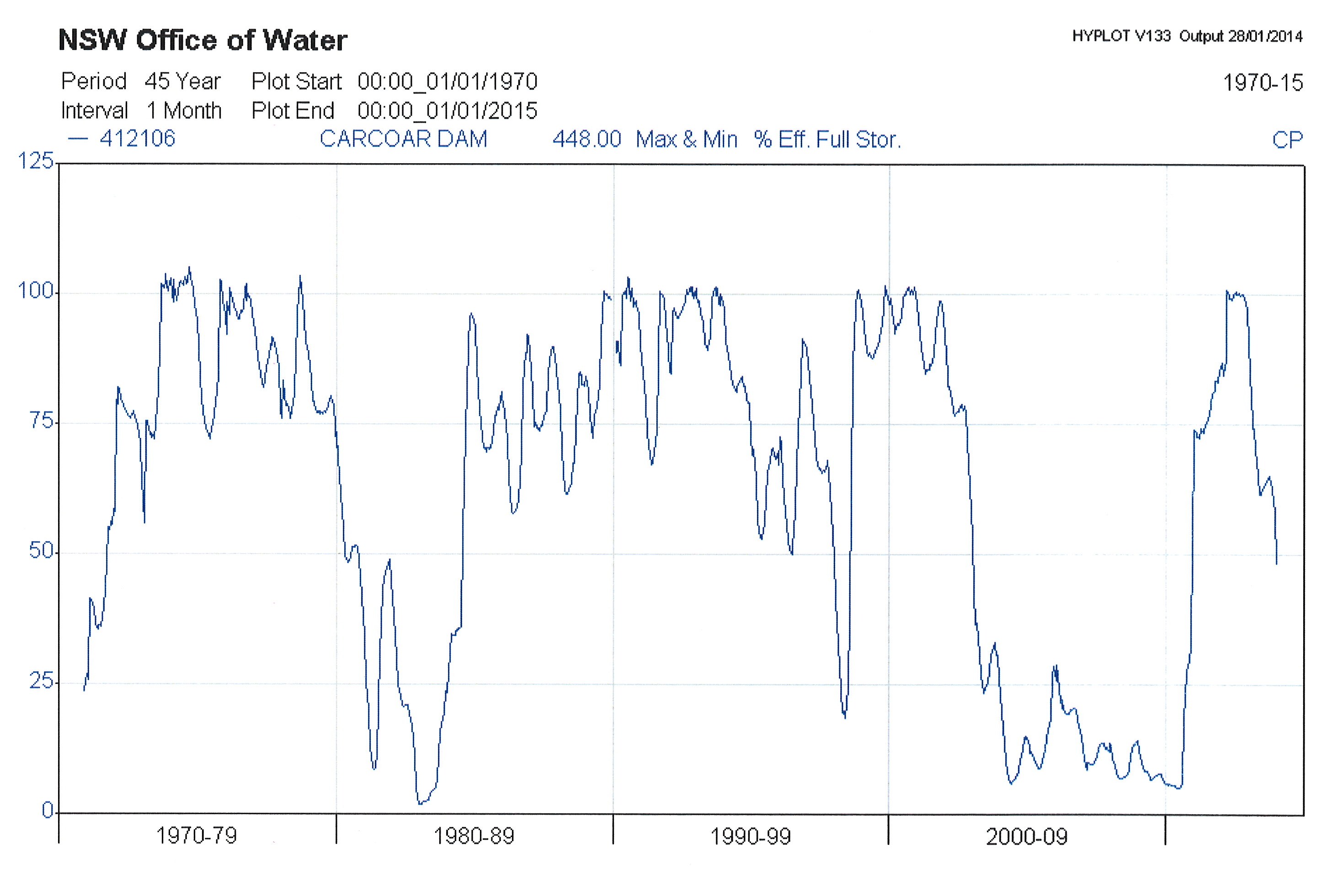
Graph showing the Effective Full Storage Volume (%) in Carcoar Dam from 1970 to January 2014 (Source: NSW Water Information or waterinfo.nsw, data extracted 28 January 2014)
Drought not only impacts on industries and communities, it also has significant effects on the catchment’s plants and animals. Decreases in runoff due to drought reduce the extent and function of wetlands in the Lachlan Catchment. Reductions in stream flows are also likely to have a negative impact on aquatic biodiversity as waterplants, fish and other aquatic animals become ‘stranded’ in isolated pools and wetland remnants due to a lack of water or suitable habitat for migration. The length and severity of drought is likely to increase stress on plants and animals.
While one of the reports used as an input to the Lachlan Environmental Water Management Plan (LEWMP) has commented that the current drought is not the major cause of the decline of water-dependent ecosystems, such as River Red Gums in the lower Lachlan (Armstrong et al., 2009), there are some concerns that this conclusion has been drawn on the basis of limited data and that actual and more recent data has not been quoted. One concern relates to the use of rainfall as an index of runoff rather than using actual Wyangala inflow data (see Wyangala drought inflows). This graph indicates that rainfall in the catchment has not translated into significant inflows to Wyangala or other storages over the last 9 years. In addition, the latest water extraction data, which is not used in Armstrong et al., 2009, indicates that over the last 7 years water extraction declined very steeply and has varied between 9500 to 109,150 ML per year, while the extraction data used in the Armstrong report was collected prior to 1997 and varied from 100,000 and 450,000 ML per year.
While the decline in water-dependent ecosystems in the Lachlan is influenced by a number of factors, including river regulation and land management, drought appears to be a major impact on a number of wetlands in the lower Lachlan. Drought also appears to increase other impacts on wetlands resulting from changes in the natural watering regime.
Water Quality & Cold Water Pollution
Water Quality and Cold Water Pollution
The Australian and New Zealand Environment and Conservation Council (ANZECC and ARMCANZ 2000) provide guidelines for fresh and marine water quality. These guidelines recommend water quality thresholds for drinking, protection of aquatic ecosystems, industry, agriculture and recreation. Objectives and targets, based on these guidelines, are provided in the National Water Quality Management Strategy, the Natural Resources Commission State-wide Targets, and the Lachlan CMA Catchment Action Plan. By meeting these targets, the critical ecological functions and habitats in the Lachlan River may be restored.
The Water Quality Allowance is included under the WSP to reduce impacts from increased salinity and blue-green algal blooms. Salinity and blue-green algal blooms, along with high turbidity and cold water pollution, are considered the major surface-water quality issues in the Lachlan region (Lachlan River Management Committee 2002). The Lachlan River experiences elevated salinity levels from time to time, particularly in the Boorowa River which can have around twice the recommended guideline (Regional State of the Environment 2009). The Water Quality Allowance may be used to provide dilution flows from Wyangala Dam, which generally has lower levels of salinity, to reduce salinity levels downstream.
Nutrient concentrations also increase in the Lachlan River with distance downstream (Lachlan Water Quality Study 2003). The high nutrient loads in the Lachlan region are thought to be the result of extensive levels of sheet, gully and stream-bank erosion, with diffuse sources contributing 95% of nutrient loads (Lachlan Catchment Management Authority 2006). These high nutrient loads are usually associated with an increased incidence of algal blooms in weir pools and lakes. Blue-green algae monitoring of rivers and storages in the Lachlan region in 2008–09 showed that algal blooms were greatest at Lake Cargelligo, with bloom conditions reported more than 50% of the time. Bloom conditions were also frequently reported in Lake Brewster (when full), Lake Forbes, Carcoar Dam and Wyangala Dam. The Lakes Cargelligo and Brewster Algal Warning System and Storage Operating Protocol, developed by the NSW Office of Water, is used to guide the use of dilution flows from Wyangala to downstream areas suffering from algal blooms.
Water temperature regulates the natural ecological processes in rivers and streams. Many dams alter the natural temperature regimes of aquatic ecosystems, creating potential for serious impacts to ecosystem productivity by reducing rates of growth and reproduction in many aquatic species. In south-eastern Australia, the greatest cause for concern is the release of unseasonably cold water from the deeper layers of thermally stratified reservoirs during warmer months. This is often referred to as cold water pollution and poses a serious threat to the viability and survival of fish and other aquatic fauna in many rivers (Preece 2004).
Wyangala Dam thermally stratifies from spring to autumn with temperature differences between top and bottom reaching up to 12°C, with releases typically drawn from the bottom of the dam via fixed level intakes. Burton and Raisin (2001) determined water temperature immediately below Wyangala Dam was lower than natural from November to March with a maximum difference of 7°C. Cold water pollution effects were thought to extend approximately 170-km downstream. While other investigations have found that there was around a 14°C impact that extended for at least 200-km downstream of the dam before temperature fully recovers. As a result of this and its significant effect on aquatic ecosystems, in the future the water licence issued to State Water for the Lachlan Catchment will include conditions requiring the development of options for mitigating Cold Water Pollution from Wyangala. Specific targets and objectives for the catchment are also included in the Lachlan Catchment Action Plan, which includes having water temperature maintained or restored to within 2°C of median levels.
Effects of Weirs and Pumps on Fish
The Effects of Weirs and Pumps on Fish
Reasons for the decline in native fish in the Lachlan River, as in other highly regulated rivers, are complex and numerous and include flow regulation, habitat degradation, reduced water quality, pest species, over-fishing, disease, loss of genetic integrity through stocking, and structures such as dams, weirs, culverts and river crossings forming barriers that prevent fish moving throughout the river (MDBC 2003). Fish attempting to migrate upstream become easy prey for birds as they gather downstream of barriers.
Weirs can also cause physical injury to fish attempting to migrate downstream with two common designs: (1) overshot, whereby the water passes over a crest, and (2) undershot, whereby the water passes under a gate (DPI 2007). Fish can be injured as they pass over the crest and fall to the bottom of the weir, and by turbulence and pressure changes as water passes under the gate. Many weirs in the Lachlan have the undershot design that is known to cause high mortality among larval and juvenile fish, for example, 95% among Golden Perch (Macquaria ambigua; Baumgartner et al. 20062). The Lake Brewster and Lake Cargelligo Fish Management and Operations Plans attempt to reduce the impact of undershot weirs on fish entering and leaving those storages.
Most irrigation occurs during the warmer months and coincides with spawning and migration, and it is highly likely that fish are being extracted from the river through channels or pumps. Even if the fish are not injured, it is very unlikely that they will be able to return to the river (MDBC undated).
Measurement of Water Extraction
Measurement of Water Extraction
Measurement of water extractions, including the reliability of meters, has been a matter of concern since volumetric allocations were introduced (Minister for Water Resources 1986; DLWC 1995). Measurement of all water extractions, including regulated river allocations, groundwater use, unregulated flows and floodplain harvesting, must be as accurate and reliable as possible. The Australian Government has developed a draft National Metering Standard Framework, and aims to provide an acceptable level of confidence whereby non-urban metering throughout Australia has a ‘maximum permissible error’ limit, in the field, of plus or minus 5%. Each state and territory will develop a plan for implementing the metering.
State Water has received funding through the Rivers Environment Restoration Program (RERP) to investigate possible savings in the regulated Lachlan River by (1) improving water delivery through acquiring real-time data from hydrometric stations and meters, (2) automating valves and structures, (3) making metering more accurate, and (4) improving water delivery through any other means.
The Australian Government has made an in-principle agreement to allocate $90 million to State Water under the Water for the Future program to replace existing customer owned meters with State Water owned meters, to be connected by telemetry. The Australian Government will convert the water savings that the project generates to environmental water licences that the Australian Government will hold.
A CSIRO review of water availability in the Lachlan, when looking at future climate and development predicted that groundwater extraction in some areas is expected to increase more than three-fold by 2030, with nearly all of the increase occurring in the Lachlan Fold Belt Groundwater Management Unit. This would mean total groundwater extraction for the region would be 440 GL/year – an increase of 86% over 2004/05 extraction levels. Predicted future groundwater extraction would (under the best estimate 2030 climate) represent 63% of total water use on average and 95% of total water use in years of minimum surface water diversion. The total eventual impacts of future groundwater extraction across the region will be an estimated additional 30 GL/year reduction in streamflow. Of this impact, streamflow leakage and the larger individual inflow reductions were included in the river modelling.
Farm dam storage capacity over the Lachlan region is projected to increase by 36,000 ML (an increase of 14% of current farm dam storage capacity) by 2030. This increase in farm dams would reduce mean annual runoff by less than 2%, which is relatively small compared to the best estimate climate change impact on runoff (10%). The best estimate of the combined impact of climate change and farm dam development is a 12% reduction in mean annual runoff.
It should be noted that CSIRO, when predicting future water usage, did not assess whether the predicted volume could be physically extracted for use. The prediction was based on the level of entitlement issued and CSIRO acknowledged “there is considerable uncertainty in the future projections of groundwater development outside of the two modelled groundwater management units” (p82, CSIRO 2008). The NSW Office of Water has since put in place statewide embargos (Gazette Notice 159, 19/12/2008) that are expected to minimise future growth in water usage.